The geology and geotechnical engineering sector is undergoing a rapid digital transformation. Today, to optimize time and precision on site, we present GMS NX, the next generation of the geomechanical survey by GeoStru.
Geomechanical Survey in the field: the revolution of the Compass NX app
- Measure the dip direction and dip of each joint using the phone’s sensors.
- Record the exact GPS coordinates.
- Instantly associate photos and a voice note to each specific discontinuity.

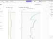
Interactive Stereographic Diagram for the Geomechanical Survey and Kinematic Analysis

The impact of Artificial Intelligence and Drones on the Geomechanical Survey
Technical innovation goes even further, introducing two features that redraw the operational boundaries of the geomechanical survey:
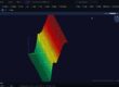
- Integration of 3D Point Clouds: GMS NX supports the import of three-dimensional clouds derived from photogrammetric drones or LiDAR scanners. The system accepts PLY and XYZ formats, smoothly managing datasets with thousands of points. Thanks to the 3D viewer, the professional is helped to recognize the discontinuity planes of the geomechanical survey: a click will be enough to automatically extract their orientation.
- Artificial Intelligence for data extraction: A unique feature in this sector! Simply paste the raw text of your notes and the artificial intelligence will extract the attitudes, projecting them in real-time onto the stereographic diagram of your geomechanical survey.

Georeferencing and Reporting
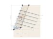
In the modern workflow of the geomechanical survey, graphic and documentary restitution is of vital importance. In GMS NX, every single joint surveyed is anchored on the real map. You can import the survey from a CSV file and the face will appear exactly on the map, using decimal coordinates in UTM projection. The user can view the data on OpenStreetMap, topographic, or satellite backgrounds of their choice.
- Structured Word report.
- DXF files for AutoCAD.
- CSV tables of the attitudes.
- High-resolution vector graphs in SVG or PNG format.
You might also be interested in
Analysis of rocky elements: guide to RockPlane NX
The calculation of slope stability is an essential operation for a proper analysis of rocky elements plan. To tackle modern geotechnical challenges, the RockPlane NX software stands out as the definitive solution to calculate the stability of these elements in both static and seismic conditions Geometric criteria in analysis of rocky elements RockPlane NX allows for…