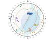
Extensively used at an international level, Slope stability analysis software – SLOPE is one of the most used software for slope stability verification of both loose and rocky soils, using the traditional methods of geotechnics (Limit Equilibrium), and the Discrete Element Method. Under seismic conditions, it is possible to choose either the pseudo static method or the simplified dynamic analysis.
A number of conventions must be used for optimal modeling of geotechnical sections, the most important of which are explained below.
The slope to be verified must always have the lowest part on the left, i.e. the coordinates of the polylines that define the profile and the layers must grow from left to right.

It is preferable that all surface coordinates (polylines of the model) have positive coordinates.

Polylines defining layers should not be inserted in a descending sequence from right to left.

The succession of layers should have an extension that does not exceed the limit of the topographic surface.

It is not possible to define layers outside of the topographic surface. After defining the topographic surface you must insert the layers with numbering in sequence from top to bottom.

The numbering of the layers should follow a correct ordering, from top to bottom (progressive ordering with higher numbers at the bottom).


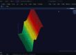
Geological and Geotechnical 3D Modeling – GM3D is the optimal solution for geological and geotechnical BIM modeling, allowing the user to create and export three-dimensional BIM models of the subsurface and geotechnical sections quickly and easily.
Thanks to its 3D modeling algorithms, GM3D offers different modeling approaches, through which it is able to reconstruct the stratigraphic terrain model and geological sections.
Lenses (polygon tool) must not be outside the topographic surface.

The pile head cannot be outside the slope, the coordinates of the anchor point can be coincident or inside the topographic surface.

The body of the pile shall not be outside the topographic surface.

The head of the anchors cannot be outside the topographic surface, it can coincide or be inside the topographic surface (convention also valid for geogrids).


The structure of the gravity wall or undeformable wall shall be internal to the topographic surface.

Demonstration videos have been published on GeoStru’s YouTube channel, some of which are shown below.


Slope stability analysis software – Slope – is the software for the verification of the stability of slopes in loose or rocky soils with the traditional methods of geotechnics (Limit Equilibrium), and the Discrete Element Method with which it is possible to calculate the displacements of the slope and examine the progressive failure. Under seismic conditions it performs both static and dynamic analysis.